Perform accurate measurements in real-time with the help of the Global Navigation Satellite System, including GPS, GLONASS, Baidu, Galileo, and any other constellation system.
Say goodbye to dead zones and hello to centimetre-level accuracy! Our range of professional surveying equipment is sourced from some of the industry’s most-respected manufacturers, including top-of-the-range brands and models.
![]()
From the handheld accuracy of the SP20 GNSS Receiver to precision field data collection with the Ranger 5 Data Collector. No matter the project, SEP have you covered.
We also stock all manner of GNSS/GPS accessories, including rover rods, GPS poles, mounts, connectors and adapters.
If you’re looking for a cost-effective solution, we offer a survey equipment hire service for all customers, or you can browse our used surveying equipment for top-quality products at affordable prices.
No matter the project. Big or small. We’ve got you covered. Not only do we sell brand-new pieces of equipment ready to hit the road, but we offer used survey equipment at affordable prices.
And for short-term jobs? We’ve got your back with fully assured and top-of-the-range survey equipment for hire. Short-term or long-term, get in touch to tailor your next job.
Broken kit? Laser level need calibrating? Bring them in. We have a whole team of quality-assured specialists for any survey equipment repairs necessary. The premium quality of our service has enabled us to become a Spectra Authorised Service Partner as well as an authorised dealer of the global brand.
Got a question? Our friendly team are here to help you with your query. No job is too small. Trust a team who knows their stuff to get the job done.
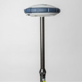
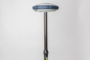
Cover all bases with our wide range of GPS/GNSS survey equipment.
While the terms are commonly used interchangeably, there are notable differences between the two. However, GPS (Global Positioning System) refers to the North American satellite system.
Whereas GNSS (Global Navigations Satellite System) uses the International Multi-Constellation Satellite System, including GPS, Baidu, GLONASS, Galileo and more.
GNSS/GPS survey equipment covers a lot of ground – literally and figuratively. Whether you’re conducting static or kinematic surveys you’ll have accurate results right when you need them.
We offer everything from centimetre accuracy network rovers, GIS data collectors and smart antennae, to GNSS receivers, multi-band RTK (real-time kinematic) receivers and more. Reach out to us to find the best solution for your project.
The Geographical Information System offers data on land, buildings and vegetation. The SP20 GNSS Receiver offers GIS Software for your land survey and mapping needs.
With the centimetre precision of GNSS technology, you can mitigate multipath errors, increase availability, continuity and reliability, and better operate in harsh environments. This is what makes GNSS the perfect solution for mapping and land surveys.
Our friendly and knowledgeable staff are happy to advise you on the best GNSS Surveying Equipment for your specific project.